IslayBlog.com -> 2007 ->

Tuesday, 25/Dec/2007
Islay, Jura and Colonsay on a Very Old Map

No rest for this Islay blog over Christmas, but then why should I take a break from something I enjoy doing? I hope I can give a little Christmas present to those interested in old maps (in particular of Islay, Jura and Colonsay) with this entry. My father has a very old atlas, we think probably published in the 18th or latest 19th century. The first page I turned to was the one of ‘Magna Britannia’ to see what I could find of Islay:

This particular map doesn't seem to have a date, but other maps in the atlas are dated 1743 and 1744, another one 1776. The map has text in three languages, German, English and Latin. The title (not visible in the pictures) reads:
A General Map of Great Britain and Ireland with Part of Holland, Flanders, France &e Agreable to modern History.
By the Heirs of late Mr Homann, at Nuremberg.
Johann Homann was a German geographer and cartographer who lived from 1664 to 1724 (more details in the German Wikipedia entry for Johann Baptist Homann). After his death the business was continued under the ‘Homann Heirs’ name until 1848.
Based on this (and the style of some of the other maps) we think the map was probably created some time in the 18th century, somewhere around 1740 to 1750.
But back to Islay, Jura and Colonsay:

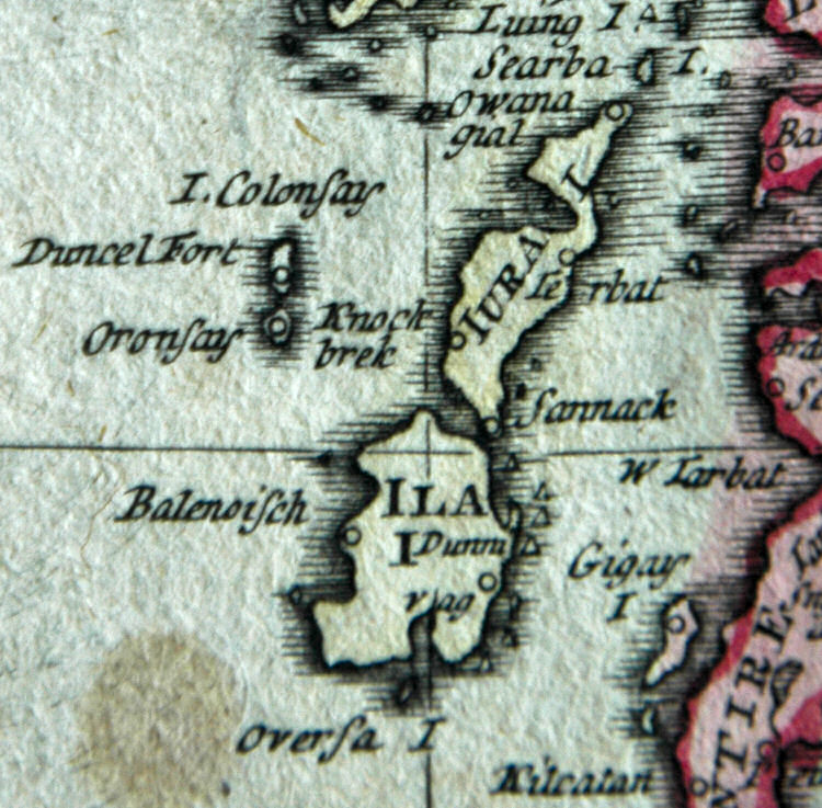
Biggerise the map of Islay, Jura and Colonsay
Quite interesting view I think. Loch Indaal doesn't seem to exist, well, apart from a tiny bit. Some of the place names are recognisable and make sense, others I'm struggling with:
Dunmvag is obviously Dunyvaig, once a stronghold of the Lords of the Isles. Knockbrek is Cnocbreac on Jura, which was once part of an important trading route (from Margadale near Bunnahabhain on Islay). Terbat (or Ierbat?) I think is Tarbert on Jura, I believe also part of the same trading route.
Others are more tricky: Sannack I think might be Sannaig on Jura, but I'm not sure why that is significant enough to show on a map? And Balenoisch on the west coast of Islay, is that Ballinaby? And finally Duncel Fort on Colonsay leaves me stumped.
Comments and suggestions for the places I can't identify (or any other thoughts and comments on the map) are very welcome...
Advertising
Navigation
[Previous entry: "Christmas Greetings from the Grewe Family"] [Home] [Next entry: "Islay (and Jura) from Kintyre"]